Tide Data for - Point Elrington, Elrington Island, Prince William Sound, Alaska

Search Tide Stations
Tide Graph and Table for
Point Elrington, Elrington Island, Prince William Sound, Alaska
(59.9383° N, 148.2270° W)
| Wednesday, April 24th, 2024 | ||
|---|---|---|
| Time | Type | Height |
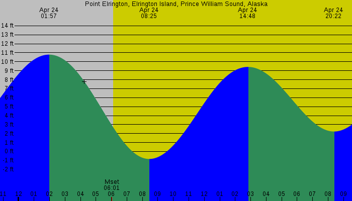
| 01:57 AM AKDT | High Tide | 10.79 feet |
| 08:25 AM AKDT | Low Tide | -0.84 feet |
| 02:48 PM AKDT | High Tide | 9.42 feet |
| 08:22 PM AKDT | Low Tide | 2.22 feet |
| Thursday, April 25th, 2024 | ||
|---|---|---|
| Time | Type | Height |
| 02:20 AM AKDT | High Tide | 10.98 feet |
| 08:59 AM AKDT | Low Tide | -0.96 feet |
| 03:21 PM AKDT | High Tide | 9.16 feet |
| 08:51 PM AKDT | Low Tide | 2.72 feet |
Raw Tide Data
Point Elrington, Elrington Island, Prince William Sound, Alaska
59.9383° N, 148.2270° W
2024-04-24 01:57 AM AKDT 10.79 feet ** High Tide **
2024-04-24 06:01 AM AKDT Moonset
2024-04-24 06:08 AM AKDT Sunrise
2024-04-24 08:25 AM AKDT -0.84 feet ** Low Tide **
2024-04-24 02:48 PM AKDT 9.42 feet ** High Tide **
2024-04-24 08:22 PM AKDT 2.22 feet ** Low Tide **
2024-04-24 09:35 PM AKDT Sunset
2024-04-24 11:31 PM AKDT Moonrise
2024-04-25 02:21 AM AKDT 10.98 feet ** High Tide **
2024-04-25 06:02 AM AKDT Moonset
2024-04-25 06:05 AM AKDT Sunrise
2024-04-25 08:59 AM AKDT -0.96 feet ** Low Tide **
2024-04-25 03:21 PM AKDT 9.16 feet ** High Tide **
2024-04-25 08:51 PM AKDT 2.72 feet ** Low Tide **
2024-04-25 09:37 PM AKDT Sunset
Tide Graphs and Charts - Point Elrington, Elrington Island, Prince William Sound, Alaska
NOT FOR NAVIGATION
The accuracy of these tide predictions is not guaranteed in any way. You should not use this program if anyone or anything could come to harm as a result of an incorrect tide prediction. NOAA and similar agencies in other countries can provide you with certified tide predictions if that is what you need.
XTide's predictions do not incorporate the effects of tropical storms, El Niño, seismic events, subsidence, uplift, or changes in global sea level.