Page 1 of 1

The Virginia Fall Line

Posted: Wed May 07, 2008 12:45 pm
by allingeneral
I was talking to a buddy of mine today about the James River blue catfish situation, apparently it has been reported in a local paper...I still need to dig that up and read it...

Anyway, the discussion turned to the "definition of the Virginia Fall Line". Now, I had a misconception about the Fall Line. I thought that it was the pretend line in each river of the Piedmont where the state had officially called it "This side of the line is brackish/salt water - the other side of the line is fresh water". Well, the State (or Commonwealth, really) has made that determination, but it isn't related at all to the term "Fall Line" like I thought it was.

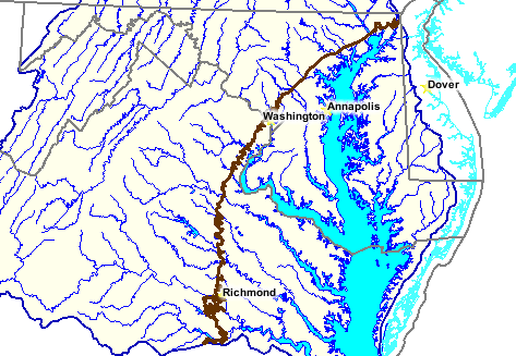
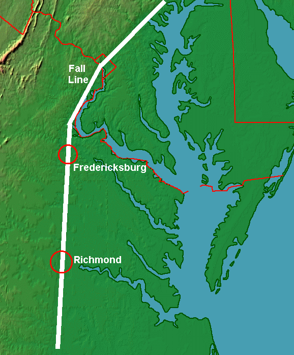
The fall line is actually the point in the Virginia Piedmont at which the hard bedrock of the Appalachian mountain ridge gives way to softer bedrock of the piedmont. This softer bedrock erodes away easier and thus water falls have developed there and it marks the start of the deeper water of the Potomac, Rappahannock and James Rivers.

More very interesting information about this topic can be found at the following website...

http://www.virginiaplaces.org/regions/fallshape.html

Image

Image

Re: The Virginia Fall Line

Posted: Thu May 08, 2008 5:52 am
by RACN35
The Fall Line is defined as the following landmarks:

Rappahannock River: Rt. 1 Bridge
Mattaponi River: Rt. 360 Bridge
Pamunkey River: Rt. 360 Bridge
Chickahominy River: Walkers Dam
James River: 14th Street Bridge
Occoquan River: I-95 Bridge

Re: The Virginia Fall Line

Posted: Thu May 08, 2008 5:52 am
by RACN35

Re: The Virginia Fall Line

Posted: Thu May 08, 2008 9:49 am
by allingeneral
and also...the following excerpt from http://www.dgif.state.va.us/fishing/reg ... rocity.asp which this information was the source of my confusion concerning the definition of "Fall Line"

Potomac River Virginia has reciprocal license agreements for three sections of the Potomac River, one above the District of Columbia and two below the District of Columbia. License requirements are different for these sections.

- - - - - - - - - - - - - - - - - - - - - - - - - - - - - - - - - - - - - - - - - - - - - - - - - - - - - - -

Upper Potomac River [above Little Falls (upper border with the District of Columbia) to the West Virginia border/state line]
Resident anglers with state freshwater licenses in Virginia or Maryland may fish the Potomac River and from both banks.

- - - - - - - - - - - - - - - - - - - - - - - - - - - - - - - - - - - - - - - - - - - - - - - - - - - - - - -

Middle Potomac and its Tidal Freshwater Tributaries (between Woodrow Wilson Bridge and Rt. 301)
Valid Virginia freshwater and saltwater (excluding county licenses), Potomac River Fisheries Commission, and Maryland Bay sport licenses are all honored on the mainstem Potomac and Maryland tributaries up to the demarcation lines (see below); all of these same licenses, except the Virginia saltwater licenses, are honored on the Virginiatributaries up to demarcation lines (see below):

Virginia tributaries up to the following demarcation lines:

* Accotink Creek: Rt. 1 Bridge
* Aquia Creek: First bridge above Aquia Harbor Marina
* Chopawansic: Rt. 1 Bridge
* Chotank: Causeway
* Dougue Creek: Rt. 235, Mt. Vernon Memorial Parkway
* Four Mile Run: Rt. 1 Bridge
* Hunting Creek: Rt. 1 Bridge
* Little Hunting Creek: Rt. 1 Bridge
* Neabsco: Rt. 1 Bridge
* Occoquan River: Fall Line
* Pohick Creek: Rt. 611 (Colchester Road)
* Potomac Creek: Rt. 608 Bridge
* Powells Creek: Rt. 1 Bridge
* Quantico Creek: Rt. 1 Bridge
* Unnamed bays and tributaries accessible by gas-powered boats.

Maryland tributaries up to the following demarcation lines:

* Anacostia River: downstream of Northeast Branch
* Bridge at northbound lane of Alternate Rt. 1
* Bladensburg Road, and Northwest Branch Bridge at
* southbound lane of Rhode Island Avenue.
* Piscataway Creek: Downstream of Rt. 224 Bridge
* (Livingston Rd.)
* Henson Run: Downstream of Oxon Hill Road Bridge
* Nanjemoy Creek: Downstream of Rt. 6 (Trappe) Bridge
* Port Tobacco Creek: Downsteam of Rt. 6 Bridge
* Mattawoman Creek: Downstream of Rt. 225 Bridge
* Unnamed bays and tributaries accessible by gas-powered boats.

- - - - - - - - - - - - - - - - - - - - - - - - - - - - - - - - - - - - - - - - - - - - - - - - - - - - - - -

Lower Potomac River (between its mouth and the Rt. 301 Bridge)
Valid Virginia saltwater (excluding County licenses), Maryland Bay sport, or Potomac River Fisheries Commission licenses are honored in the main stem. In Virginia tributaries below 301, Virginia freshwater and saltwater, and Potomac River Fisheries Commission licenses are honored.

Re: The Virginia Fall Line

Posted: Fri May 09, 2008 4:57 am
by RACN35
crazy aint it ? Image