Tide Data for - Fort Pierce Inlet, south jetty, Florida

GFF Tide Prediction Graphs and Tables
Search Tide Stations
Tide Graph and Table for
Fort Pierce Inlet, south jetty, Florida
(27.4700° N, 80.2883° W)
| Friday, April 3rd, 2026 | ||
|---|---|---|
| Time | Type | Height |
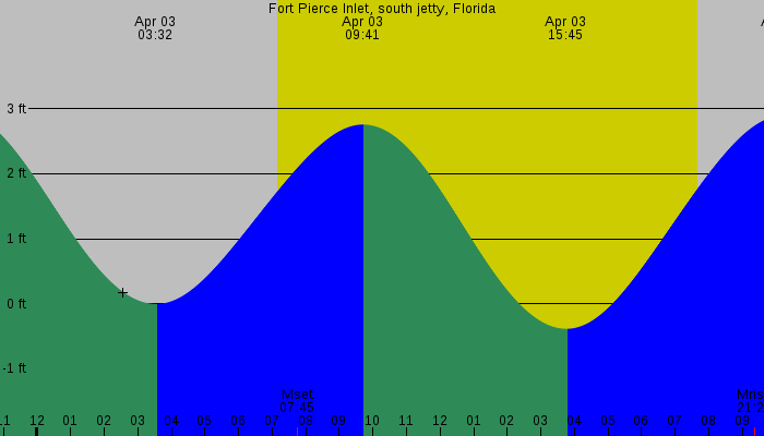
| 03:32 AM EDT | Low Tide | 0.00 feet |
| 09:41 AM EDT | High Tide | 2.76 feet |
| 03:45 PM EDT | Low Tide | -0.39 feet |
| 10:10 PM EDT | High Tide | 2.89 feet |
| Saturday, April 4th, 2026 | ||
|---|---|---|
| Time | Type | Height |
| 04:09 AM EDT | Low Tide | 0.13 feet |
| 10:16 AM EDT | High Tide | 2.67 feet |
| 04:21 PM EDT | Low Tide | -0.23 feet |
| 10:46 PM EDT | High Tide | 2.77 feet |
⭐ Premium Boat Gear on Amazon


As an Amazon Associate we earn from qualifying purchases.
Prices and availability are subject to change.
Prices and availability are subject to change.
Raw Tide Data
Fort Pierce Inlet, south jetty, Florida
27.4700° N, 80.2883° W
2026-04-03 03:32 AM EDT -0.00 feet ** Low Tide **
2026-04-03 07:09 AM EDT Sunrise
2026-04-03 07:45 AM EDT Moonset
2026-04-03 09:41 AM EDT 2.76 feet ** High Tide **
2026-04-03 03:45 PM EDT -0.39 feet ** Low Tide **
2026-04-03 07:39 PM EDT Sunset
2026-04-03 09:22 PM EDT Moonrise
2026-04-03 10:10 PM EDT 2.89 feet ** High Tide **
2026-04-04 04:09 AM EDT 0.13 feet ** Low Tide **
2026-04-04 07:08 AM EDT Sunrise
2026-04-04 08:19 AM EDT Moonset
2026-04-04 10:16 AM EDT 2.67 feet ** High Tide **
2026-04-04 04:21 PM EDT -0.23 feet ** Low Tide **
2026-04-04 07:40 PM EDT Sunset
2026-04-04 10:19 PM EDT Moonrise
2026-04-04 10:46 PM EDT 2.77 feet ** High Tide **
Tide Graphs and Charts - Fort Pierce Inlet, south jetty, Florida
NOT FOR NAVIGATION
The accuracy of these tide predictions is not guaranteed in any way. You should not use this program if anyone or anything could come to harm as a result of an incorrect tide prediction. NOAA and similar agencies in other countries can provide you with certified tide predictions if that is what you need.
XTide's predictions do not incorporate the effects of tropical storms, El Niño, seismic events, subsidence, uplift, or changes in global sea level.